

Unlocking Earth’s Topography: Understanding SRTM C-Band and X-Band DEM Products
The SRTM mission, launched by NASA in 2000, changed the way we map the Earth by creating the first near-global high-resolution elevation data. Its two main products—C-band (wide coverage, deeper ground detection) and X-band (higher detail, smaller coverage)—have helped countries like Indonesia improve flood mapping, infrastructure planning, and environmental monitoring. This mission filled major data gaps and continues to support smarter, more sustainable decisions around the world
The Shuttle Radar Topography Mission (SRTM) was a collaborative project between NASA, the National Geospatial-Intelligence Agency (NGA), and other international partners, launched in February 2000 aboard the Space Shuttle Endeavour. Its primary objective was to collect high-resolution elevation data for most of the Earth’s land surface, covering latitudes between 60°N and 56°S. The mission used Interferometric Synthetic Aperture Radar (InSAR) technology to map terrain in three dimensions, producing one of the most extensive digital elevation datasets available to the public.
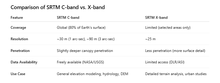
Two radar systems were mounted during the mission: C-band (5.6 cm wavelength) operated by NASA and X-band (3 cm wavelength) operated by the German and Italian space agencies. The SRTM C-band data covered around 80% of the Earth's land surface and is widely available in 1 arc-second (~30 m) and 3 arc-second (~90 m) resolutions. Meanwhile, the SRTM X-band data, though offering higher resolution and finer detail in many areas (up to ~25 m), had much more limited coverage, focusing primarily on selected regions of interest.
The SRTM C-band is widely used for applications such as hydrological modeling, watershed delineation, regional planning, and infrastructure development due to its consistent global coverage and public availability. In contrast, the SRTM X-band, with its finer detail and higher resolution, is more suited to urban mapping, landslide analysis, and detailed terrain evaluation, especially in regions with limited vegetation. However, the limited spatial coverage and access restrictions make it more specialized and less commonly used than C-band.
In practice, the two datasets can be complementary. C-band data provides a broad and consistent elevation baseline, while X-band can be used for higher-detail analysis in selected hotspots. As such, understanding the strengths and limitations of each is key for researchers, planners, and analysts who aim to make informed decisions based on topographic data.
Related Products
© 2025. All rights reserved.


LOCATION
East Kalimantan,Indonesia