
Digital Elevation Model (DEM)
Digital Elevation Model (DEM) is a representation of the Earth's surface that captures terrain elevation data in a digital format. DEMs are primarily derived from satellite imagery (such as NASA’s SRTM and ASTER), aerial photogrammetry, LiDAR scans, and topographic surveys. These models play a crucial role in applications like hydrology, land-use planning, disaster management, and environmental monitoring.
Multi-Spectral
Multispectral imaging systems typically capture data in multiple discrete spectral bands, ranging from visible light (red, green, and blue) to near-infrared (NIR) and shortwave infrared (SWIR). These systems are mounted on satellites, drones, and aircraft, and they utilize specialized sensors to differentiate materials based on their reflectance properties. The number of bands varies depending on the application, with common sensors using 4 to 10 bands.
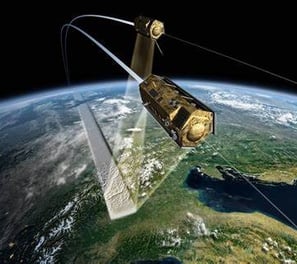

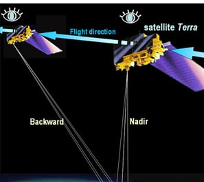
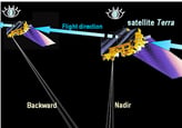
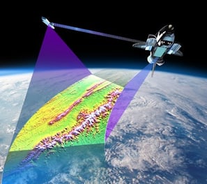


Image Processing/Transformation
Digital Elevation Model (DEM) is a representation of the Earth's surface that captures terrain elevation data in a digital format. DEMs are primarily derived from satellite imagery (such as NASA’s SRTM and ASTER), aerial photogrammetry, LiDAR scans, and topographic surveys. These models play a crucial role in applications like hydrology, land-use planning, disaster management, and environmental monitoring.
Spatial Modelling
Spatial modeling is a powerful analytical method used to simulate, understand, and predict real-world phenomena based on geographic data. By integrating spatial relationships, patterns, and environmental variables, spatial modeling helps researchers, planners, and decision-makers explore complex systems such as land use change, climate impacts, biodiversity distribution, or urban growth. It transforms raw spatial data into meaningful insights, making it an essential tool for solving real-world problems and guiding evidence-based planning and policy
Connect
info@datacitra.id
© 2025. All rights reserved.


LOCATION
East Kalimantan,Indonesia